Apple Expands Maps Transit Directions to Seattle, Washington - MacRumorsOpen MenuShow RoundupsShow Forums menuVisit ForumsOpen Sidebar
Skip to Content

Apple Expands Maps Transit Directions to Seattle, Washington

by

Apple today updated its Maps app to add Transit information in Seattle, allowing iOS users living in the city to incorporate public transportation options like the Link Light Rail, Monorail, buses, and more into Maps when seeking directions.

Transit directions within Maps became available with the launch of iOS 9, and while Apple offered directions in a limited number of cities to begin with, the availability of Transit directions has since expanded to encompass 16 cities around the world along with dozens of cities in China.

seattletransitdirections
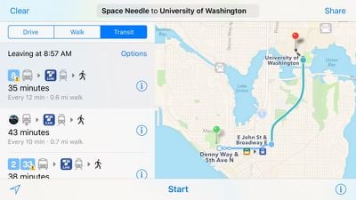
Apple's iOS 9 Feature Availability page has not yet been updated with the addition of Seattle, but the information should be added in the near future. Including Seattle, Transit directions are now available in Austin, Texas; Baltimore, Maryland; Berlin, Germany; Boston, Massachusetts; Chicago, Illinois; London, England; Los Angeles, California; Mexico City, Mexico; Montreal and Toronto, Canada; New York City, New York; Philadelphia Pennsylvania; San Francisco, California, Sydney Australia; and Washington, DC.

Though also unlisted on the Feature Availability page, Transit directions were also added for Portland, Oregon last Monday.

Top Rated Comments

doelcm82 Avatar
133 months ago
1 city per news = 2 000 000 news on MacRumors about Transit updates.


2 000 000, the approx. number of cities in the world
150 comments per post. They'll be rolling in the dough.

But seriously, once Apple starts rolling out more than one city a week, MacRumors will group several cities into one post. Just as they do with Flyover cities.
[doublepost=1461004466][/doublepost]
This is going to take forever if they keep adding cities this slow... How small is the maps team for gods sake? And is there just one team for the whole planet???
They have recently gone from one city every few months to one city a week. That suggests they are getting better at integrating the data. It won't progress fast enough to satisfy everyone, but it appears they are accelerating.
Score: 3 Votes (Like | Disagree)
133 months ago
Apple should buy citymapper and add 50 more cities.
Score: 1 Votes (Like | Disagree)
tylsimp Avatar
133 months ago
Seems like all bus systems in the Seattle area are integrated too. Which is good, since it's a massive jumbled mess around here.
If you use the Orca NFC card, you can transfer between King County Metro Busses, Seattle Department of Transit Street Cars, and Sound Transit busses and rail at no extra cost for 90 minutes. If you pay in cash, ST offers no transfers, and KC paper transfers are only valid on KC busses. The Monorail is unfortunately privately owned and not part of any fare integration, being set up as a tourist thing, $2.50 for a one way ticket, though monthly passes are available for the few that use it to commute. Hopefully this will change in the near future, because it does run frequently and is certainly the fastest way possible to get between downtown and Seattle Center/Queen Anne neighborhood.
[doublepost=1461025093][/doublepost]This is super exciting! AM is a lot more aesthetically pleasing than GMaps and I think the UI is a little better, so it's great to finally have an alternative.
This actually would have been much more useful before Link Light Rail started running to the University of Washington last month. Before that, I had to rely on busses and time schedules... now I know a train will be there every 6-10 minutes, depending on the time of day. I just walk down there and hop on!

I will have to test this out sometime, though. Last time I tried Google's transit directions - a year or two ago - it didn't handle Seattle's downtown transit tunnel very well. Google tried to steer me towards a stop that the bus in question (a 73, in all likelihood) didn't use except late at night. :D
GMaps and Apple Maps are almost certainly using the same resources from King County/OneBusAway for bus routes, schedules, stops and realtime arrival. In my experience, there are certainly issues, but not enough to possibly make me go back to learning and researching timetables. 99% good. Apple Maps is prettier. It'll probably be as buggy.
Score: 1 Votes (Like | Disagree)
133 months ago
Slowest rollout ever. Step it up Apple.
Score: 1 Votes (Like | Disagree)
SBlue1 Avatar
133 months ago
This is going to take forever if they keep adding cities this slow... How small is the maps team for gods sake? And is there just one team for the whole planet???
Score: 1 Votes (Like | Disagree)
Shirasaki Avatar
133 months ago
Other Washington. The Capitol is the city in D.C., and the state on the other side of the country is the one with Seattle and rain.
Oh, my bad. Know little about United States. Thank you.
Score: 1 Votes (Like | Disagree)

Popular Stories

Apple Maps General

Apple Maps Flyover Gets a Visual Upgrade in iOS 27

Monday June 8, 2026 4:29 pm PDT by
Apple Maps is getting a visual update in iOS 27, with Apple planning to introduce new aerial imagery that's combined with Visual Intelligence models. Apple said everything will have sharper detail, from the "shapes of individual trees to the way light reflects off the glass of skyscrapers." Flyover is an Apple Maps view that lets users see more than 350 cities in 3D with detailed...
Apple Says iOS 27 Adds These 12 New Features to Your iPhone Feature

Apple Says iOS 27 Adds These 12 New Features to Your iPhone

Tuesday June 9, 2026 9:47 am PDT by
iOS 27's key new feature is a more intelligent and personal version of Siri, but the changes go well beyond that. In a press release, Apple outlined additional enhancements coming across Apple Maps, Find My, Apple Wallet, Apple Music, and more. Apple Maps has gained an enhanced Flyover experience powered by AI, enabling you to view aerial imagery in "stunning detail" for select cities. In ...
liquid glass app icon

Apple Maps to Get These 10 New Features in iOS 27

Thursday June 11, 2026 5:45 am PDT by
Apple Maps is getting a range of new features in iOS 27, headlined by an upgraded Flyover experience that uses AI to improve the realism and detail of its aerial imagery. Flyover is a longstanding feature of Apple Maps and lets users explore more than 350 cities in 3D with detailed landmarks, roads, parks, and buildings. Apple described the enhanced Flyover in iOS 27 as combining aerial...