Apple Maps Vehicles Have Now Collected Street View Data in Over 40 States and 10 Countries - MacRumorsOpen MenuShow RoundupsShow Forums menuVisit ForumsOpen Sidebar
Skip to Content

Apple Maps Vehicles Have Now Collected Street View Data in Over 40 States and 10 Countries

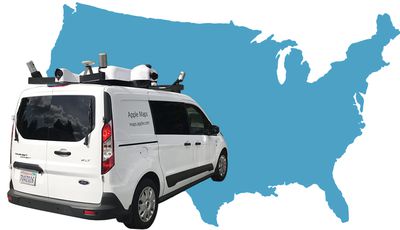
Apple Maps vehicles equipped with LiDAR equipment have now surveyed at least 41 states in the United States, with recent areas including Maine and Iowa, as the fleet of vans continue to collect mapping data across the country.

apple van

Image via MacRumors forum member AngerDanger

The vehicles first took to the streets in major American cities like New York in 2015, and they have since traveled to Croatia, France, Ireland, Italy, Portugal, Slovenia, Spain, Sweden, and the United Kingdom. Apple periodically updates a list of locations where the vehicles will be collecting data on its website.

Apple's page notes that it will "blur faces and license plates on collected images prior to publication," suggesting that the company is working on a feature similar to Google's Street View for Apple Maps.

Back in 2015, Mark Gurman reported that Apple planned to launch a 3D street view feature, based on a combination of its existing Flyover mode with street-level data. He also said the data would help Apple shift to an in-house mapping database by 2018, reducing its reliance on third-party sources like TomTom.

At the time, Gurman said Apple did not believe that Google's classic Street View interfaces were intuitive to users, and as a result, he said the company was exploring new ways to present that kind of imagery.

Google launched Street View way back in 2007, so if Apple is truly working on its own competing feature, then it will presumably have points of differences. Otherwise, it is certainly possible that the vehicle-collected data will only be used for storefront imagery or other underlying mapping improvements.

When Apple's fleet of vans first hit the streets, it was speculated they could be the basis of an Apple Car. But those rumors quieted down after the vans were labeled with Apple Maps decals, and because Apple has shifted towards testing self-driving software with Lexus 450h SUVs near its headquarters in California.

It's too early to say when Apple will fully take advantage of the data it has collected, but with parts of at least 80 percent of the United States now surveyed, the fruits of the labor could be witnessed sooner rather than later.

Popular Stories

Apple Maps General

Apple Maps Flyover Gets a Visual Upgrade in iOS 27

Monday June 8, 2026 4:29 pm PDT by
Apple Maps is getting a visual update in iOS 27, with Apple planning to introduce new aerial imagery that's combined with Visual Intelligence models. Apple said everything will have sharper detail, from the "shapes of individual trees to the way light reflects off the glass of skyscrapers." Flyover is an Apple Maps view that lets users see more than 350 cities in 3D with detailed...
Apple Says iOS 27 Adds These 12 New Features to Your iPhone Feature

Apple Says iOS 27 Adds These 12 New Features to Your iPhone

Tuesday June 9, 2026 9:47 am PDT by
iOS 27's key new feature is a more intelligent and personal version of Siri, but the changes go well beyond that. In a press release, Apple outlined additional enhancements coming across Apple Maps, Find My, Apple Wallet, Apple Music, and more. Apple Maps has gained an enhanced Flyover experience powered by AI, enabling you to view aerial imagery in "stunning detail" for select cities. In ...
liquid glass app icon

Apple Maps to Get These 10 New Features in iOS 27

Thursday June 11, 2026 5:45 am PDT by
Apple Maps is getting a range of new features in iOS 27, headlined by an upgraded Flyover experience that uses AI to improve the realism and detail of its aerial imagery. Flyover is a longstanding feature of Apple Maps and lets users explore more than 350 cities in 3D with detailed landmarks, roads, parks, and buildings. Apple described the enhanced Flyover in iOS 27 as combining aerial...

Top Rated Comments

107 months ago
Apple maps is terrible. Only use when you want to not find where you need to go.
Not Sure how you can say that Apple Maps is “terrible”, which could be variable based on someone’s experience in location. I use Apple Maps every single day and it’s never failed me. It’s greatly improved from where it was once, and it gives me all the necessary information I need to get to my destination the quickest and best route. I don’t even use Google maps anymore, even though Google maps is very good.
Score: 39 Votes (Like | Disagree)
107 months ago
Apple Maps van has one jacked up tire and a flat. No wonder maps can't find ****! Lol
Score: 30 Votes (Like | Disagree)
Joe Rossignol Avatar
107 months ago
Apple Maps van has one jacked up tire and a flat. No wonder maps can't find ****! Lol
I suck at Photoshop :p

EDIT: @AbSoluTc I've done my best attempt to re-inflate the tires... :oops: :D
Score: 27 Votes (Like | Disagree)
billybobthornton Avatar
107 months ago
We don’t need another Google Maps! Focus on better products please!
Score: 24 Votes (Like | Disagree)
chrono1081 Avatar
107 months ago
Not Sure how you can say that Apple Maps is “terrible”, which could be variable based on someone’s experience in location. I use Apple Maps every single day and it’s never failed me. It’s greatly improved from where it was once, and it gives me all the necessary information I need to get to my destination the quickest and best route. I don’t even use Google maps anymore, even though Google maps is very good.
Part of the problem is people never used it since its first and second year and just assume its terrible. IMO it's far better than Google Maps. It navigates better and finds just about the same amount of places. I find its more accurate too for road closings.
Score: 18 Votes (Like | Disagree)
deannnnn Avatar
107 months ago
The problem is that street view imagery gets so outdated so fast... are they really planning on using 2015 imagery of New York? There's a restaurant on my block that has changed 3 times since then!
Score: 16 Votes (Like | Disagree)