Apple Maps Now Provides Transit Directions Across Belgium - MacRumorsOpen MenuShow RoundupsShow Forums menuVisit ForumsOpen Sidebar
Skip to Content

Apple Maps Now Provides Transit Directions Across Belgium

by

Following yesterday's Apple Pay launch in Belgium, Apple today updated its Maps app to include transit information across the country.

belgium transit apple maps
Apple has yet to update its official list of locations for which Maps offers Transit data, but several tipsters contacted MacRumors to confirm the information is already live.

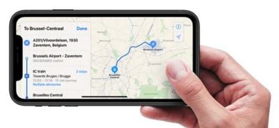
The coverage includes train, tram, and bus routes in the main cities as well as other funicular connections around the country. Belgian connections to nearby connections abroad also feature in Apple's coverage.

Google Maps has supported transit directions for several years now, but Apple Maps has been adding transit data since 2015 and is steadily catching up with detailed routing information.

(Thanks Bernd and Noah!)

Top Rated Comments

NightFox Avatar
99 months ago
I'm always amused by the drop shadow some editors add to images of illuminated touchscreen devices; it just looks like a Maps sticker on an iPhone. It'd be like drawing an illuminated lightbulb with a shadow on one side. Here's what it ought to look like:

I think that's actually dust under the screen due to the iPhone's lack of dust filter.
Score: 4 Votes (Like | Disagree)
99 months ago
This is nice to see.

It seems like Apple is not just redoing maps in the U.S. (this lists where their maps vehicles have been will be over the last weeks / next weeks and a chunk of them are not in the U.S.):

https://maps.apple.com/vehicles/
Score: 3 Votes (Like | Disagree)
McFreggle Avatar
99 months ago
Wow! Tim Cook suddenly came to realize that Belgium actually exists?

What's next for us? Apple News and the HomePod? Come on! You can do it, Apple!
Score: 3 Votes (Like | Disagree)
99 months ago
This is nice to see.

It seems like Apple is not just redoing maps in the U.S. (this lists where their maps vehicles have been will be over the last weeks / next weeks and a chunk of them are not in the U.S.):

https://maps.apple.com/vehicles/
Apple has been building their own base map for several years now and has thousands of people working on it. And it has been a worldwide effort from the start. Those "street view" vehicles have been worldwide for almost two years now.
Score: 2 Votes (Like | Disagree)
99 months ago
Apple also enabled transit directions in Philippines a couple of weeks ago, and Iowa recently.

Atlanta, Melbourne, and Brisbane Airports all now have indoor maps as well.

It also appears that Apple's new maps have gone online in Hawaii.
Score: 2 Votes (Like | Disagree)
KazKam Avatar
99 months ago
Apparently folks on Apple's Map and Pay teams got a hankering for waffles.
Score: 2 Votes (Like | Disagree)

Popular Stories

Apple Maps General

Apple Maps Flyover Gets a Visual Upgrade in iOS 27

Monday June 8, 2026 4:29 pm PDT by
Apple Maps is getting a visual update in iOS 27, with Apple planning to introduce new aerial imagery that's combined with Visual Intelligence models. Apple said everything will have sharper detail, from the "shapes of individual trees to the way light reflects off the glass of skyscrapers." Flyover is an Apple Maps view that lets users see more than 350 cities in 3D with detailed...
Apple Says iOS 27 Adds These 12 New Features to Your iPhone Feature

Apple Says iOS 27 Adds These 12 New Features to Your iPhone

Tuesday June 9, 2026 9:47 am PDT by
iOS 27's key new feature is a more intelligent and personal version of Siri, but the changes go well beyond that. In a press release, Apple outlined additional enhancements coming across Apple Maps, Find My, Apple Wallet, Apple Music, and more. Apple Maps has gained an enhanced Flyover experience powered by AI, enabling you to view aerial imagery in "stunning detail" for select cities. In ...
liquid glass app icon

Apple Maps to Get These 10 New Features in iOS 27

Thursday June 11, 2026 5:45 am PDT by
Apple Maps is getting a range of new features in iOS 27, headlined by an upgraded Flyover experience that uses AI to improve the realism and detail of its aerial imagery. Flyover is a longstanding feature of Apple Maps and lets users explore more than 350 cities in 3D with detailed landmarks, roads, parks, and buildings. Apple described the enhanced Flyover in iOS 27 as combining aerial...