Apple Maps Vehicles to Begin Surveying Belgium and the Netherlands
Apple Maps vehicles will begin surveying Belgium and the Netherlands during June, according to a list of locations maintained on Apple's website.
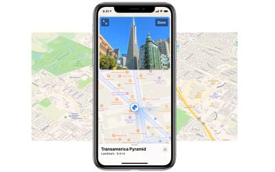
The data collected will be used to improve Apple Maps and to expand its Look Around feature, which remains limited to a handful of U.S. cities. Introduced in iOS 13, Look Around is similar to Google's Street View, providing a street-level view of supported locations with high-resolution 3D imagery that can be zoomed and panned.
One advantage of Look Around over Street View is smoother panning when moving around the map for a more immersive experience. As with Street View, Apple blurs faces and license plates in all of the 3D imagery that it makes available.
Apple Maps vehicles have also surveyed parts of the United States, Canada, United Kingdom, Ireland, Italy, France, Spain, Sweden, Slovenia, Portugal, Croatia, Japan, Andorra, and Puerto Rico since data collection began in 2015. In some areas where streets are not easily accessible, Apple uses employees wearing a backpack system to collect data.
Popular Stories
Apple Maps is getting a visual update in iOS 27, with Apple planning to introduce new aerial imagery that's combined with Visual Intelligence models.
Apple said everything will have sharper detail, from the "shapes of individual trees to the way light reflects off the glass of skyscrapers."
Flyover is an Apple Maps view that lets users see more than 350 cities in 3D with detailed...
iOS 27's key new feature is a more intelligent and personal version of Siri, but the changes go well beyond that. In a press release, Apple outlined additional enhancements coming across Apple Maps, Find My, Apple Wallet, Apple Music, and more.
Apple Maps has gained an enhanced Flyover experience powered by AI, enabling you to view aerial imagery in "stunning detail" for select cities.
In ...
Apple Maps is getting a range of new features in iOS 27, headlined by an upgraded Flyover experience that uses AI to improve the realism and detail of its aerial imagery.
Flyover is a longstanding feature of Apple Maps and lets users explore more than 350 cities in 3D with detailed landmarks, roads, parks, and buildings. Apple described the enhanced Flyover in iOS 27 as combining aerial...