Apple Maps Gains AR Walking Directions in Tokyo, Japan - MacRumorsOpen MenuShow RoundupsShow Forums menuVisit ForumsOpen Sidebar
Skip to Content

Apple Maps Gains AR Walking Directions in Tokyo, Japan

In iOS 15, Apple's Maps app includes the ability to use augmented reality walking directions in some big cities, and today we learn that Tokyo has become the latest place that you can use it.

japan tokyo ar walking directions maps
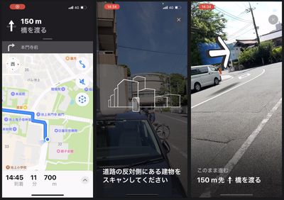
The AR mode can map walking directions onto the real world by using your iPhone's rear camera, making it easier to see where you need to go in built-up areas and reducing the need to look down at your smartphone as you move.

The feature's availability in Tokyo was discovered by Ata Distance, who also says other Japanese city maps may have been updated beyond Tokyo, but it's hard to know without being on the ground.

To initiate a walking route, iPhone users can raise their ‌device‌ and scan the buildings around them when prompted. The step-by-step directions will appear in the AR mode automatically, which should make it easier to get where you need to go, especially in situations where the directions are tricky.

According to Apple's feature availability page, AR walking directions are available in London, Los Angeles, Montréal, New York Philadelphia, San Diego, San Francisco Bay Area, Singapore, Toronto, Vancouver, and Washington, DC. Japan has yet to be added to the list.

Popular Stories

Apple Maps General

Apple Maps Flyover Gets a Visual Upgrade in iOS 27

Monday June 8, 2026 4:29 pm PDT by
Apple Maps is getting a visual update in iOS 27, with Apple planning to introduce new aerial imagery that's combined with Visual Intelligence models. Apple said everything will have sharper detail, from the "shapes of individual trees to the way light reflects off the glass of skyscrapers." Flyover is an Apple Maps view that lets users see more than 350 cities in 3D with detailed...
Apple Says iOS 27 Adds These 12 New Features to Your iPhone Feature

Apple Says iOS 27 Adds These 12 New Features to Your iPhone

Tuesday June 9, 2026 9:47 am PDT by
iOS 27's key new feature is a more intelligent and personal version of Siri, but the changes go well beyond that. In a press release, Apple outlined additional enhancements coming across Apple Maps, Find My, Apple Wallet, Apple Music, and more. Apple Maps has gained an enhanced Flyover experience powered by AI, enabling you to view aerial imagery in "stunning detail" for select cities. In ...
liquid glass app icon

Apple Maps to Get These 10 New Features in iOS 27

Thursday June 11, 2026 5:45 am PDT by
Apple Maps is getting a range of new features in iOS 27, headlined by an upgraded Flyover experience that uses AI to improve the realism and detail of its aerial imagery. Flyover is a longstanding feature of Apple Maps and lets users explore more than 350 cities in 3D with detailed landmarks, roads, parks, and buildings. Apple described the enhanced Flyover in iOS 27 as combining aerial...

Top Rated Comments

54 months ago
This really makes me miss Japan, really wanna go back soon.
Score: 3 Votes (Like | Disagree)
MozMan68 Avatar
54 months ago
I tried this out in NYC last year and was pretty impressed. Of course, I couldn't stop watching it as I was walking which you're not really supposed to do..Hah.

Video HERE ('https://youtu.be/JRSWadtnPBQ')
Score: 3 Votes (Like | Disagree)
54 months ago
Good to see it being available in another city too. But want it to be available in many more cities. Hope that happens.
Score: 2 Votes (Like | Disagree)
54 months ago

Do they work equally as well in English in Tokyo? Or Japanese in Toronto?

I suspect that I would want names of places, streets, etc. to be in both English and Japanese were I wandering round Tokyo. The English to understand, and the Japanese to compare with signs.
Most streets don't have names in Tokyo, so that's not really an issue. Apple maps (and Google, for that matter) already lists place names in English (romanized). I'll try out the AR walking thing later this weekend maybe.

Attachment Image
Score: 2 Votes (Like | Disagree)
54 months ago
Can’t wait to use this with AR glasses someday
Score: 1 Votes (Like | Disagree)
MozMan68 Avatar
54 months ago

Nice, but really wish they would do more frequent satellite imagery updates for my area. I know they are using 5+ year old images since I put Solar on my house 5 years ago March and it still doesn't show. Probably doesn't matter in many locations, but I'm in a rapid growth area. What is odd is they use different imagery for the Maps app on MacOS (about 2 years old) vs iOS or iPadOS. GoogleMaps is about a year old.
This is one feature I truly don;t understand...and honestly, haven't looked into that much...but we all know there are companies taking very detailed satellite images of the entire Earth on a daily basis but I'm sure the cost is high, cloudy days, stitching like images together, 3D views which are not satellite necessarily, etc.

My guess is that like LookAround in the USA, Apple is putting together a complete update that will hopefully blow us away like 3D/flyover type satellite across the country....or not...
Score: 1 Votes (Like | Disagree)