Apple Maps Expands Transit Data to Honolulu and Kansas City - MacRumorsOpen MenuShow RoundupsShow Forums menuVisit ForumsOpen Sidebar
Skip to Content

Apple Maps Expands Transit Data to Honolulu and Kansas City

by

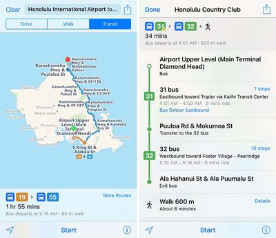
Apple Maps has been updated with comprehensive transit data for the U.S. cities of Honolulu, Hawaii and Kansas City, Missouri, enabling iPhone users in the areas to navigate using public transportation, including buses and commuter rails.

Apple-Maps-Transit-Kansas-City
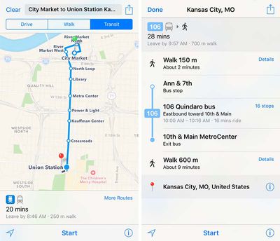
Transit routing options in the Kansas City metropolitan area include RideKC buses and the downtown KC Streetcar. Directions extend to most suburbs in both Kansas and Missouri, including Overland Park, Olathe, Independence, Lee's Summit, Shawnee, Blue Springs, Lenexa, and other smaller communities.

Transit routing options in Honolulu include TheBus buses, with directions extending to destinations across the entire Oahu island.

Apple-Maps-Transit-Honolulu
Apple introduced Transit in Maps as part of iOS 9 in select cities around the world, including Baltimore, Berlin, Boston, Chicago, London, Los Angeles, Mexico City, New York, Philadelphia, San Francisco, Sydney, Toronto, and 30 cities in China.

The feature has since expanded to a number of additional cities and regions around the world, including Atlanta, Denver, Miami, Montréal, Portland, Rio de Janeiro, Sacramento, Seattle, and New South Wales, Australia.

(Thanks, Ram!)

Top Rated Comments

heeloliver Avatar
130 months ago
Kansas City represent!
Score: 3 Votes (Like | Disagree)
truettray Avatar
130 months ago
Awesome. Now I can know how late our useless streetcar will be to pick me up to go nowhere.
Score: 2 Votes (Like | Disagree)
130 months ago
I find these transit updates to be WAY more useful than the flyovers. Hopefully they will focus more on transit. :)
Score: 1 Votes (Like | Disagree)
Gasu E. Avatar
130 months ago
All these little US Cities!! What about East Blobnigburg in the Republic of Crocknia?!!! Fess up, Apple, you hate Crocknians!
Score: 1 Votes (Like | Disagree)

Popular Stories

Apple Maps General

Apple Maps Flyover Gets a Visual Upgrade in iOS 27

Monday June 8, 2026 4:29 pm PDT by
Apple Maps is getting a visual update in iOS 27, with Apple planning to introduce new aerial imagery that's combined with Visual Intelligence models. Apple said everything will have sharper detail, from the "shapes of individual trees to the way light reflects off the glass of skyscrapers." Flyover is an Apple Maps view that lets users see more than 350 cities in 3D with detailed...
Apple Says iOS 27 Adds These 12 New Features to Your iPhone Feature

Apple Says iOS 27 Adds These 12 New Features to Your iPhone

Tuesday June 9, 2026 9:47 am PDT by
iOS 27's key new feature is a more intelligent and personal version of Siri, but the changes go well beyond that. In a press release, Apple outlined additional enhancements coming across Apple Maps, Find My, Apple Wallet, Apple Music, and more. Apple Maps has gained an enhanced Flyover experience powered by AI, enabling you to view aerial imagery in "stunning detail" for select cities. In ...
liquid glass app icon

Apple Maps to Get These 10 New Features in iOS 27

Thursday June 11, 2026 5:45 am PDT by
Apple Maps is getting a range of new features in iOS 27, headlined by an upgraded Flyover experience that uses AI to improve the realism and detail of its aerial imagery. Flyover is a longstanding feature of Apple Maps and lets users explore more than 350 cities in 3D with detailed landmarks, roads, parks, and buildings. Apple described the enhanced Flyover in iOS 27 as combining aerial...