Revamped Apple Maps Now Available in Texas, Louisiana, and Southern Mississippi
Last year, Apple announced plans to rebuild its Maps app with its own first-party data. The overall look and feel of Apple Maps is similar, but zooming and panning reveals more details like grass, trees, sports fields, and parking lots. Apple is also focused on making search results more relevant.
The improvements first rolled out in Northern California in July 2018, followed by Hawaii and Southern California in November 2018, and Arizona, New Mexico, and the Las Vegas metropolitan area in April 2019.
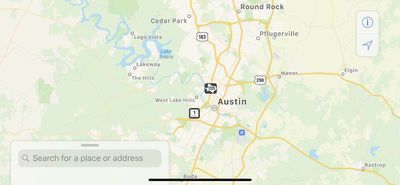
Now, the updated data is available across Texas, Louisiana, and the southern half of Mississippi, as Apple continues its pattern of rolling out the updated maps in adjacent continental U.S. states. Zooming into these regions displays more details and greenery in Apple Maps across the iPhone, iPad, and Mac.
At WWDC 2019, Apple said the updated maps will roll out to the entire United States by the end of the year, followed by additional countries in 2020.
(Thanks, Trevor K. and Chet C.!)
Popular Stories
Apple Maps is getting a visual update in iOS 27, with Apple planning to introduce new aerial imagery that's combined with Visual Intelligence models.
Apple said everything will have sharper detail, from the "shapes of individual trees to the way light reflects off the glass of skyscrapers."
Flyover is an Apple Maps view that lets users see more than 350 cities in 3D with detailed...
iOS 27's key new feature is a more intelligent and personal version of Siri, but the changes go well beyond that. In a press release, Apple outlined additional enhancements coming across Apple Maps, Find My, Apple Wallet, Apple Music, and more.
Apple Maps has gained an enhanced Flyover experience powered by AI, enabling you to view aerial imagery in "stunning detail" for select cities.
In ...
Apple Maps is getting a range of new features in iOS 27, headlined by an upgraded Flyover experience that uses AI to improve the realism and detail of its aerial imagery.
Flyover is a longstanding feature of Apple Maps and lets users explore more than 350 cities in 3D with detailed landmarks, roads, parks, and buildings. Apple described the enhanced Flyover in iOS 27 as combining aerial...