

Google Maps for iOS Gains Live Traffic Info for Buses, Transit Crowdedness Predictions - MacRumorsOpen MenuShow RoundupsShow Forums menuVisit ForumsOpen Sidebar
Skip to Content

Google Maps for iOS Gains Live Traffic Info for Buses, Transit Crowdedness Predictions

by

Google today announced a major update for Google Maps on both Android and iOS, introducing new transit-related features.

Google Maps will now provide details on live traffic delays for buses in places where real-time information doesn't exist from local transit agencies, which will let Maps users see if a bus will be late, how long the delay might be, and how long travel might take.


The app will provide details on exactly where delays are on the map so riders will know what to expect before getting on a bus.

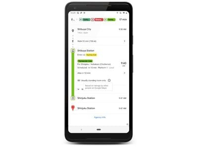
Along with live traffic information for buses, Google is adding crowdedness predictions for transit routes. Based on past ride information, Google Maps will offer up details on how crowded a bus, train, or subway is likely to be.
googletransitcrowdedness
The new Google Maps features are rolling out today on Android and iOS in close to 200 cities around the world.

Top Rated Comments

94 months ago
As someone who uses the busses a lot in the UK, I’m really excited for these new features!
The ‘crowdedness’ sounds awesome because sometimes busses are so full that you’ll have to stand.
I assume it’ll work the same way as how google shows how busy a shop is at certain times.
Score: 2 Votes (Like | Disagree)
94 months ago
Assuming it ends up being accurate, it will be interesting to see if anyone finds value in it. Maybe I am missing the use case where this will be of any value. First, is there any bus system in the world that people don't expect to be crowded during rush hour and not crowded during off hours? Second, if you're taking the bus, it's because the vast majority of times you don't have a choice, so how many people will change their behavior based on this information? In other words, when you are waiting for your bus, if your mapping service tells you the one coming is crowded, what are you going to do differently? Again, 99.9% of the time, whether your bus is going to be crowded is not exactly going to be a news flash for people.
Score: 1 Votes (Like | Disagree)
marvin_h Avatar
94 months ago
For a company the size of google and with an ostensibly class leading map service, the lack of obvious features is fascinating.

Where is the option to tell maps how large your vehicle is? Weight, length, height, etc, to prevent using roads that are inappropriate? Eg, clearance height, allowable weight on bridges, turning radius, and other common restrictions?

Glad to see these new features getting rolled out but would be great to cover the basics first no?

Google today announced ('https://www.blog.google/products/maps/grab-seat-and-be-time-new-transit-updates-google-maps/') a major update for Google Maps on both Android and iOS, introducing new transit-related features.

Google Maps will now provide details on live traffic delays for buses in places where real-time information doesn't exist from local transit agencies, which will let Maps users see if a bus will be late, how long the delay might be, and how long travel might take.


The app will provide details on exactly where delays are on the map so riders will know what to expect before getting on a bus.

Along with live traffic information for buses, Google is adding crowdedness predictions for transit routes. Based on past ride information, Google Maps will offer up details on how crowded a bus, train, or subway is likely to be.

MacRumors content image

The new Google Maps features are rolling out today on Android and iOS in close to 200 cities around the world.

Article Link: Google Maps for iOS Gains Live Traffic Info for Buses, Transit Crowdedness Predictions ('https://www.macrumors.com/2019/06/27/google-maps-for-ios-transit-update/')
Score: 1 Votes (Like | Disagree)
Westside guy Avatar
94 months ago
Based on my experiences in Seattle, they could just hard-code “Crowded? YES” and “Running Late? YES” for Metro Transit busses and leave it at that.
Score: 1 Votes (Like | Disagree)

Popular Stories

Apple Maps Google Maps Icons

Google Maps Showing 'Lake America' in U.S., Apple Maps Yet to Follow

Monday August 31, 2026 6:33 am PDT by
Google Maps users in the U.S. will now see the name "Lake America" instead of "Lake Ontario" for the Great Lake that straddles the New York—Ontario border. Google said it made this change in response to the U.S. Geographic Names Information System (GNIS) updating the name for "Lake Ontario" to "Lake America," following an executive order issued by U.S. President Donald Trump last week....
google ai student discount

College Students Can Get a Free Year of Google AI Pro

Wednesday August 19, 2026 12:00 pm PDT by
Google today said eligible college students in the United States can get a free year of Google AI Pro. Google AI Pro is normally priced at $19.99 per month, and it includes 4x higher usage limits in Gemini, access to Gemini Spark, Gemini in Google apps like Gmail and Google Docs, and 5TB of storage space. Eligible college students outside the United States can get a free year of Google AI...
iOS 27 Next to iPhone

Here's When iOS 27 Rolls Out Today in Every Time Zone [Update: It's Out]

Sunday September 13, 2026 3:00 am PDT by
Update 10:04 a.m.: iOS 27 is rolling out now, though it may take a bit for all users to see it, so keep checking! Apple is about to release iOS 27, which will finally deliver more advanced Siri AI capabilities as well as a variety of other refinements, improvements, and new features to iPhones. It's Apple's biggest software update of the year, and Apple announced at Wednesday's iPhone event...